Longitude by Dava Sobel
In literally hundreds of instances, a vessel’s ignorance of her longitude led swiftly to her destruction.
Background
Longitude — written by Dava Sobel — tells the story of the multi-century quest to reliably determine one’s longitude1 at sea.
While this might seem like a bizarre issue in today’s world — we all have GPS phones! — it was a very serious problem.
Thousands upon thousands of sailors died at sea because they literally did not know where they were. They either starved to death because they couldn’t find land to replenish supplies or they crashed into rocks and drowned.
After one particularly disastrous shipwreck, Britain passed the Longitude Act of 1714 where they would award the equivalent of about $4 million in today’s dollars for a reliable solution to the longitude problem.
At the time it was deemed impossible. Or as Sobel puts it:
The search for a solution to the longitude problem assumed legendary proportions, on a par with discovering the Fountain of Youth, the secret of perpetual motion, or the formula for transforming lead into gold.
The many failed attempts
Even prior to the Longitude Act, some of the smartest people on the planet came up with incredibly clever solutions to solve the longitude problem.
Here are some of the more serious attempts over the years:
Lunar Distance Method Proposed by Johannes Werner (1514), later refined by astronomers like Tobias Mayer and Nevil Maskelyne. This method used the moon’s position relative to fixed stars to determine time. By measuring the angular distance between the moon and a star, and comparing it to precomputed tables (adjusted for a reference time, like Greenwich), sailors could calculate longitude. It required precise astronomical observations and instruments like the sextant. While eventually somewhat effective, it was complex and weather-dependent, as clear skies were needed.
Jupiter’s Moons Method Proposed by Galileo Galilei in 1612. Galileo observed that the moons of Jupiter (discovered by him in 1610) had predictable eclipses. He suggested using these as a celestial clock: by observing the timing of the moons’ eclipses and comparing them to precomputed tables, a sailor could determine time and thus longitude. While viable on land, the method was impractical at sea due to the difficulty of using a telescope on a moving ship and the need for clear skies.
Magnetic Variation Method Proposed by Edmond Halley (of Halley’s Comet) in 1692. This method relied on the variation (or declination) of the Earth’s magnetic field, which differs by location. Halley theorized that mapping magnetic variation globally could allow sailors to estimate longitude by comparing local magnetic readings with known values. However, the method was unreliable because magnetic variation changes over time and is affected by local anomalies, making it insufficiently precise for navigation.
Signal Rockets (Fireworks) Method Proposed by William Whiston and Humphry Ditton in 1714. Whiston and Ditton suggested firing rockets or cannons from fixed stations at sea at specific times (e.g., midnight Greenwich time). Ships within sight or sound range could note the time of the signal and compare it to their local time to calculate longitude. This idea was impractical due to the vastness of the ocean, weather interference, and the inability to deploy such stations globally.
Star Occultation Method Proposed by Amerigo Vespucci (conceptually) in 1499; later refined by astronomers like Tycho Brahe; Brahe’s more systematic observations came in the late 16th century (1570s–1590s). This method involved observing when a star disappeared behind the moon (an occultation) and comparing the event’s timing to a reference location. Vespucci claimed to have used it during his voyages, but the method was impractical at sea due to the need for precise instruments and the rarity of observable occultations.
Notice how incredibly complex each of those solutions was. They required precise measurements (taken from a rocking ship), detailed maps (many of which required 30+ years of data to compile) and clear skies (which you could go weeks without at sea).2
John Harrison — instead — decided to build a watch that could reliably keep time on the ocean. This invention became known as a marine chronometer.
The idea is that you set your watch to Greenwich Mean Time (GMT) and you can compare the local time to GMT to calculate how many hours, minutes, and seconds East or West you are from Greenwich. Since the Earth has 360 degrees, this time difference can be translated into a number of degrees East or West.
Instead of needing to rely on clear skies, taking precise measurements and spending hours comparing them to your maps, you can just compare local time to the time on your ship’s marine chronometer.
Pretty amazing!
Why was this so hard?
John Harrison wasn’t the first one to come up with the idea of using a watch to solve the longitude problem but the consensus was that such a watch was impossible to build.
Watches historically relied on pendulums to keep time and pendulums were easily impacted by the rocking of a boat at sea. Especially rough seas.
Once John created a pendulum that could deal with ocean swells (an incredible accomplishment in its own right), he realized that the metals and oils in his watch were impacted by the changing temperatures and humidity the boat faced. Even moderate changes in temperature would change the viscosity of the oils used to lubricate the watch and would change the pace at which it kept time.
Harrison had to come up with a “frictionless” watch that used no oils. He also had to craft the watches with metals that had opposing properties. If one metal swelled as temperatures rose, he paired it with another metal that shrank. Harrison was truly a pioneer here, the first watchmaker to utilize materials like diamonds.
Even once he solved all of these problems, he had to deal with the fact that the watch simultaneously needed to be waterproof and to be wound each day. Making it more waterproof made it harder to wind and vice versa.
I could go on but the point is that Harrison — a self-educated man from the backwaters of England — had to solve 5+ problems that previous watchmakers had all determined to be impossible.
And he couldn’t just solve 1 or 2 of them, he had to solve ALL of them before it would work.
The watches themselves
Harrison eventually created four watches — H1 through H4 — before being satisfied with his solution.
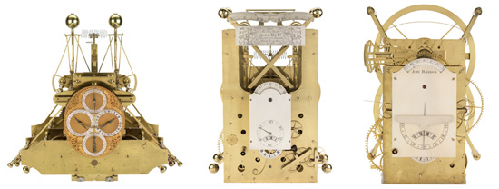
Here is an image of H1, H2 and H3.
Notice how none of these look like the watches you see today. Each of them weighed 50+ pounds and were incredibly complex.
Harrison spent five years on H1, four years on H2, and a whopping 19 years creating H3.
In general, each watch was heavier and more complex from the previous watch.
Then H4 happened.
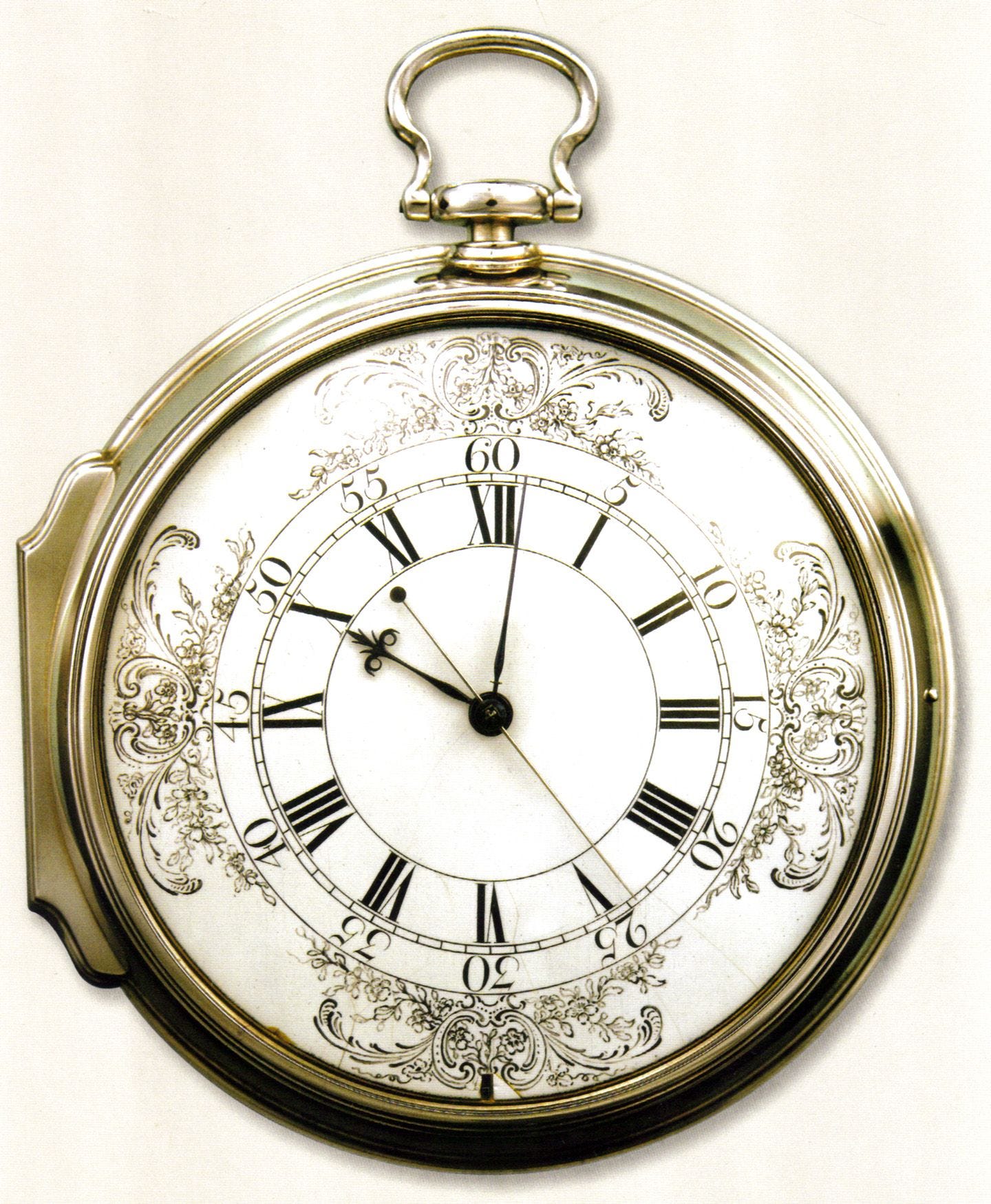
H4 took six years to build but was radically different than the previous three.
Instead of increasingly complex, large watches, H4 looked like a….. pocket watch.
Again — H1 through H3 were all 70+ pound watches that had diameters around ~4 feet and all of the sudden H4 weighed 3 pounds and had a 5 inch diameter.
It solved all of the deficiencies of the previous watches while being ~25x lighter and ~10x smaller.
It was so accurate and so drastically simple that the government forced John to build another watch from scratch believing the first one part witchcraft.
Incredible.
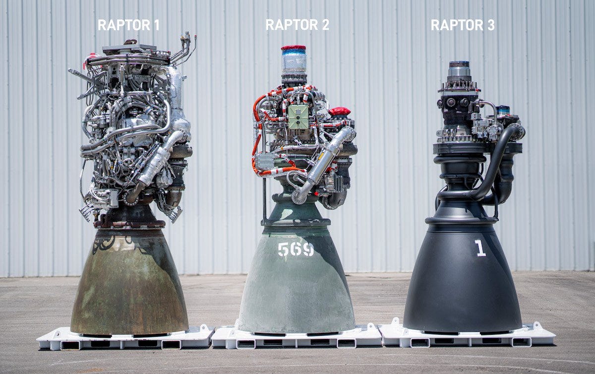
This reminded me in part of SpaceX’s Raptor engines. With each evolution, it has gotten smaller, simpler and better.
Arbitrary problems
There was a great quote in the book about the difference between latitude and longitude:
The zero-degree parallel of latitude is fixed by the laws of nature, while the zero-degree meridian of longitude shifts like the sands of time.
The point is latitude was easier to calculate because the Earth truly did behave differently as you moved towards the equator.
Seasons were different
The amount of sunlight you had was different
The angular velocity of the Earth’s rotation was different
We had magnetic poles to help guide us
Longitude on the other hand was completely arbitrary.
Being one degree east or west of Greenwich doesn’t really mean anything.
The only reason Greenwich became 0 degrees is because Britain was the major world power at the time, they solved the longitude problem and they made all of the maps.
But the fact that longitude was harder to solve — exponentially harder — because it was arbitrary has really stuck with me.
Try to avoid arbitrary problems and if you encounter a longitude problem, try to do everything you can to ground it in reality so that you can turn it into a latitude problem.
TL;DR
We take it for granted but knowing where we are on the oceans is incredibly important. It allows ships (and crews) to safely cross oceans and deliver us all of the goods we need to make modern civilization function.
We spent hundreds of years — and had some of the world’s brightest minds — working on a solution to the longitude problem. Common wisdom was that you needed to have a reference point in the sky to solve it but the best solution was actually to build a reliable watch.
The watch was an interesting case where he had many obstacles to overcome (rocking of the ocean, temperature / humidity changes, water to name a few) and his watch wouldn’t work unless he solved all of them.
There is beauty in simplicity and Harrison’s ultimate watch — H4 — was far simpler and ~25x lighter and ~10x smaller than any of his previous watches.
These solutions can come from anywhere. John Harrison was a self-educated watchmaker who lived far away from London, Oxford or Cambridge.
Arbitrary problems are harder to solve than non-arbitrary problems because non-arbitrary problems have real world reference points you can base your solutions on.
Longitude is East-West and latitude is North-South.
I do want to note that in a sense, these atsronomers were right. Today’s GPS works by launching satellites into space and having a device ping them. By measuring the time it takes to ping 3 separate satellites, we can “triangulate” our precision with remarkable accuracy. However, we first needed to being to launch satellites in space and build tiny computers to run these calculations for us in real time. So even though they were right, they were 200-500 years ahead of their time!


